【Situation】
Situated in the eastern half of the Akan-Mashu National Park in East Hokkaido, Kawakami Sub-Prefecture, Teshikaga Town. The highest point is Kamuinupuri (also known as Mt. Mashu), situated on the southeastern rim at 857m.
【Altitude at Lake Surface】
The surface of the lake is 351m above sea level. The top of the surrounding steep crater rim is between 500 and 700m above sea level, with Kamuinupuri (Mt. Mashu) jutting steeply to the southeast. The crater walls rise between 150m and 350m above the lake surface.
【Size】
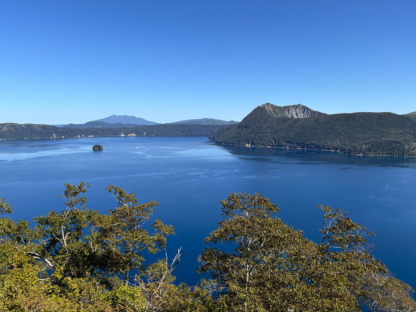
The maximum length of Lake Mashu is 6.75km, as measured from south-west to north-east, from the No.1 Observatory to Ura-Mashu Observatory. The maximum width of the lake is 3km. The surface area is 19.6k㎡, and the shore length is 20km. Kamuishu Island, in the middle of the lake, protrudes 30m above the lake surface with a length of 110m (measured southeast to northwest) and a width of 40m.
【Lake Depth】
The lake is reported to have a maximum depth of 212m, and an average depth of 146m. Depth measurements taken around Kamuishu Island indicate that the island is in fact only the apex of a lava dome, a smaller volcano that later erupted inside the Mashu caldera. The lake base is mostly flat at a depth of around 200m, rising steeply at an angle of 50 to 70 degrees at its edges.
【Water level and Hydrology】
According to measurements taken over the past 30 years, the water level is currently higher than in the past. (As of the year 2016) The relative lack of change in water level is thought to be caused by fissures in the crater walls, which allow water to steadily seep out. Such permeation is evident in numerous springs, such as in nearby Biruwa and on the north side of Kawayu Onsen station.
【Lake Bed Composition】
The composition of the lakebed nearest to the shore is rock and sand. From a depth of 35m to 209.5m the composition changes to a mixture of rock, sand, red mud, mud, etc. The ratio of sand to mud is roughly 50/50. According to sediment analysis conducted in Hokkaido (1972), much sediment is finely ground pumice.
【Lake Mashu Origin and Topography】
The Lake Mashu caldera is the remains of a stratovolcano that formed on the eastern side of the much larger Kussharo caldera (diameter 26km east-west by 20km north-south). It is separated from Lake Kussharo by the Atosanupuri mountains. The base of the volcano was 150m above sea level, with a radius of 8-10km. This volcano shape is still clearly visible from the south and west sides where the towns of Kawayu, Biruwa, Teshikaga and Nijibetsu are located. The collapse of the upper part of the volcano then created the caldera and its characteristic shape.
【Geology of Lake Mashu environs】
Geological evidence that Mashu was once a highly active volcano can be seen in the crater walls, which contain remains of lava flows and pyroclastic flows such as ignimbrite deposits.
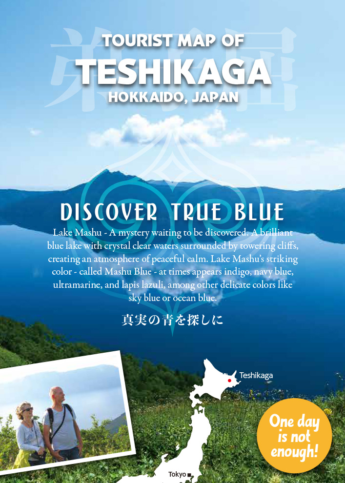
The Story of Lake Mashu
With a circumference of 20km and a surface area of 19.6km2 it is the sixth largest caldera lake in Japan. The word caldera has roots in the Latin word “caldaria”, and in Spain and Portuguese it also means cooking pot, not dissimilar to the English word cauldron of the same origin. A caldera forms when a volcano erupts and collapses, leaving a large depression that then fills with water to form the lake.
Mashu Lake is distinguished by its deep color. Two reasons for this may be its relatively high elevation at 351m above sea, and the steep cliffs angled at an average of 45 degrees that are up to 350m high. Also, the maximum depth is 212m, making it the fifth deepest lake in Japan.
In addition, because there are no inlets bringing plankton or sediment into the lake, it is suggested that it is the clearest lake in the world. To protect its pristine condition, no people are allowed near the lake shore at any time, and it enjoys a special protection status along with its national park status.
The origin of Lake Mashu
The Mashu caldera was a volcano that formed as a parasitic cone inside the much larger Kussharo Caldera, which was formed from a giant volcano that began life some 300,000 years ago. The Kussharo volcano was highly active up until around 30,000 years ago, until it finally settled into its current shape. It is the largest caldera in Japan, even larger than the famous Aso Caldera, and is amongst one of the largest calderas in the world.
The Mashu volcano started erupting frequently from around 8000 years ago. About 7000 years ago, a particularly large eruption caused the collapse of the volcano and the formation of a caldera. The pyroclastic flow from this eruption engulfed the Teshikaga area with volcanic debris several meters deep, and volcanic ash covered the entire Kushiro-Nemuro region.
Over a period of a few thousand years, the caldera slowly filled with water to form a large lake. The formation and subsequent eruption of Mt. Mashu (Mt. Kamui, Kamuinupuri) on the east side of the lake about 4000 years ago reduced the size of the lake by a quarter, and roughly completed the shape of the caldera we are familiar with now.
Mt. Mashu erupted powerfully for the final time about 1000 years ago, creating a large crater. The size of the eruption is estimated to be 10 times as powerful as that of Mt. Usu in 1977. Kamuishu Island, in the middle of the lake, is the apex of a lava dome that mostly lies below the lake’s surface and formed around the same time.
The Waters of Lake Mashu
The entrancing color of Lake Mashu’s water comes from its remarkable transparency. As there are no inlets, the water is free of plankton, sediment, and other polluting elements. The only water source is rain. The purity of the clear “Mashu Blue” water gives it a vivid color, reminiscent of indigo and sapphire.
As there are no rivers or outlets running from Lake Mashu, the level of water is maintained by the steady inflow of rainwater. The sheer volume and weight of the lake’s water itself creates enough pressure to force water through cracks or fissures below the lake’s surface. This water wells up as spring water in many spots at lower elevations. Therefore, Lake Mashu is a natural dam that will continue to nurture the surrounding nature and its inhabitants for generations to come.
Foggy Lake Mashu
During the peak viewing season for the half year from May to October, on average only 137 days are clear, whilst 54 days are partially clear, and 29 days are completely covered in Mashu’s famous fog. In fact, in June and July, this is the case for one day in four. The fog is so well-known that it gave the inspiration for the hit enka song “Kiri no Mashuko” or “The Fog of Lake Mashu”.
Just as sorrow can turn to joy in an instant, many visitors are enthralled by the sudden swings in Mashu’s mood – the lake shrouds itself in mysterious fog but then suddenly reveals itself in all its splendor.
A Window on the World
Just as its deep waters perfectly reflect the blue skies above it, Lake Mashu is also a mirror providing us with information about the atmosphere above us. Put simply, this is because the only water Lake Mashu receives comes directly from the skies in the form of rainwater. Therefore, Lake Mashu is a precious resource used for monitoring and evaluating our changing environment.
Name Origins
Many local towns, rivers and lakes in Hokkaido maintain a similarity to the original names that were first given to them by the Ainu, the native people of the island. For example, the nearby Kussharo lake was called “Kutcharo”, roughly meaning “river mouth from where lake water flows”.
However, Mashu was originally called “Kintan Kamui to” or “Lake of God in the Mountain” by the Ainu, so it would appear that the name Mashu has different origins:
One story says that it was given its new name because seagulls were often seen flying at the lake, hence “Mashi Un To” or “Seagull Lake”.
Another story goes that an old lady looking for her grandchild came to the lake. Tired and weeping for her lost child, she transformed into the island in the middle of the lake, known as Kamuishu Island. Hence, “Ma” meaning island, and “Shu” meaning old lady.
There are other stories about the origins of the name Mashu, probably just as many as there are mysteries about the lake itself!
The Legend of the Amemasu
According to Ainu folklore, the amemasu are giant fish creatures that live in lakes, irregularly causing havoc such as earthquakes and other natural disasters. It is said that the amemasu of Lake Mashu was particularly large. One day a deer came to drink at the lakeshore, and the amemasu swallowed it whole. Unfortunately, the deer’s antlers tore open the amemasu’s belly and it died. However, the amemasu was so large that it blocked up the underground water passage to the Nishibetsu River, and the lake became swollen and in danger of overflowing. The people upstream, aware of the danger, escaped to higher ground. However, the people downstream refused to heed the warnings. They found the amemasu’s body and gleefully dragged it out of the lake. The water came rushing down so fiercely that everything downriver was washed away. Such was the force of the flooding that it created what is now called the Konsengenya Plain.
Lake Mashu Flora
Because Lake Mashu is in a northern temperate zone that can be considered sub-polar, it is not unusual to see alpine plants even at the lower altitudes where the lake sits. Erman’s birch, Japanese alpine cherry, thalictrum, Dactylorhiza aristate, marsh tea, and mountain harebells are beautiful alpine plants that are all found here. Artemisia tsuneoi, a rare type of mugwort that is endemic to this area, is highly protected due to its need for stable rocky areas of land.
The Mashu caldera has been harboring plant life for 7 millennia. Japanese ash, Japanese lime, Manchurian elm, Sakhalin fir and Ezo spruce are amongst the varied tree life in the area.
The Cave of Matsuura Takeshiro
 Matsuura Takeshiro (1818 – 1888) was a Japanese explorer, cartographer, poet, painter, priest, and antiquarian who journeyed many times to Ezo (modern day Hokkaido) as well as Sakhalin and Kurile Islands. He is considered one of the most important influential figures in the history of Hokkaido. A skilled cartographer, the length and breadth of Hokkaido on foot over several visits. His surveys also covered human geography and suggestions for the development of the land, and they had huge geographic, literary, and political significance. It is suggested that his pen name “Hokkaido jin” was the basis for the island’s modern name, Hokkaido.
In 1858, he visited Lake Mashu, climbing down to the shore, and staying in a cave used for hunting and resting by the local Ainu. The cave is still located on the eastern edge of the lake under the shadow of Mount Mashu/Kamuinupuri, though access is restricted due to the need to protect the lake from human visitations.
The Blessing of Eternal Springs
Though it has long been suspected that many springs and rivers in the area surrounding Lake Mashu were fed by the lake, it was only until relatively recently that it could be mathematically and scientifically proven that this was indeed the case. For example, by measuring the amount of rainfall entering the lake on any given day and comparing to the delayed changes in water volume at the source of local rivers, the water volume patterns could be shown to match. This indicates that Lake Mashu water is steadily and slowly streaming through underground channels. Also, analyzing the mineral composition of water at various places indicate that the water source is the same. And so, the blessings of the lake appear to extend wide and far beyond its steep cliff enclosure.
The Legend of Kamuishu Island
 Kamuishu Island rises just 30m just above the water in the middle of Lake Mashu, but it is actually the top of a lava dome that extends a further 210 meters below the surface. Legend has it that a powerful chieftain was killed at the Wakkanai Kotan (village), but his mother managed to escape into the night with the chieftain’s child. However, the child was lost in the mountains, and the old lady was doomed to search for her grandchild for many days and nights until she finally reached Lake Mashu. Here, she asked the god of the lake to provide her with shelter for one night. Tired and weeping from her search, she lay down, never to move again. It is said that if you visit the island, the old lady will believe that her grandchild has returned and will weep joyous tears of rain or snow.
Mount Mashu
 To the eastern edge of Lake Mashu lies Mount Mashu, its rocky outline rising above the lake to a height of 857m. The Ainu revered the mountain and called it Kamuinupuri, meaning the mountain of god. From the 1st Observatory Station, a strenuous but beautiful 3-hour hike along the ridge of the crater will take you to the peak, from where there is a spectacular view of the lake, the cavernous Mount Mashu crater, the Konsengenya plain, and the Akan and Shiretoko mountain ranges stretching far into the distance.